Balzac’s Paris: History & Modern Walking Tour
- SUBSCRIBE
- ALREADY SUBSCRIBED?
BECOME A BONJOUR PARIS MEMBER
Gain full access to our collection of over 5,000 articles and bring the City of Light into your life. Just 80 USD per year.
Find out why you should become a member here.
Sign in
Fill in your credentials below.
 When I was young and first read the novels of Honoré de Balzac, I imagined his Paris was like the city I knew, only older. Ladies and gentlemen wore gloves, streets were lighted, at least some of the time, by gas lamps that had to be lit every evening and snuffed out at dawn, there were no cars but horses, and crottin (the residue of horses), everywhere—and the verb for cleaning shoes in those days, and still today, was décrotter which you can translate as “to decrap.” For the rest, however, I imagined it was the same in size and appearance, minus the Eiffel Tower, of course. Perhaps you did too, even if you had visited. You were wrong and so was I.
Paris is small compared to other great cities. Excluding the Bois de Boulogne and the Bois de Vincennes, which were annexed to the city around 1930, and depending on how and from where you measure, it is a little more than thirty square miles. London, which like Houston and Moscow tends to swallow up adjacent towns, is about six hundred square miles. The island of Manhattan is only five or six square miles smaller than Paris. Small can be beautiful and stylish, even magnificent, and certainly in Balzac’s day the Arc de Triomphe, the Louvre, and the Place des Vosges were where they are now, and there were other great streets and squares, but they did not define Paris as they do today.
For the most part, even past Balzac’s death in 1850, most of the city dated from the late Middle Ages and the first century or two of the Renaissance, more aptly characterized by dilapidated half-timbered houses than by elegant sandstone and wrought iron. The Place des Vosges, which went up in the early seventeenth century, was a unique marvel of urban planning and renewal—and remained one of a kind for two hundred and fifty years. Writers in the nineteenth century described Paris as small, dark, smoky, unhealthy, and dirty. It was. Balzac himself, the chronicler of Parisian life, lived in Passy, which was a semi-rural suburb at the time.
It was also cramped, a word we don’t usually think of when we wander around Paris. Here’s how to get an idea of how Paris looked and felt before Baron Haussmann began rebuilding Paris in 1853. Walk down the two remaining blocks of the Rue de la Harpe in the Fifth Arrondissement. Ignore the tourist-trappy cafés and restaurants on the ground floors. Look instead at the buildings themselves—narrow and shallow. And look at the street. The Mairie of Paris claims it is twelve meters wide, about thirty-nine feet. It is not. From house front to house front it is about twenty-three feet. Not so small, we might think, except this was one of the main north-south roads on the Left Bank for shipping in goods. Rue de la Harpe was longer then, running into what became more or less Boulevard Saint Michel (after a lot of house destruction and street straightening), but even narrower as it passed the Luxembourg Garden.
The commerce of the city was choking on traffic, the air was polluted by wood smoke and open sewers, often running down the middle of streets, and it was impossible to police. It may be unkind to suspect that Emperor Napoléon III was more concerned about public order than by assuring delivery of food and promoting public health when he decided to rebuild Paris, but it contributed. In 1853, he chose Georges-Eugène Haussmann, the Prefect of Paris who later gave himself the title of Baron, to supervise the work. He was literally and figuratively a bulldozer. He had the force of character, and the Emperor’s backing, so getting his way proved easy enough. He knocked down about forty-five percent of the existing structures in Paris and, most importantly as I see it, enlarged the city while he broadened its streets.
 Look at the historical map of Paris to the right. The outside line, l’Enceinte de Thiers, shows the city’s fortifications, well beyond the city limits. That line is approximately equal to les Boulevards des Maréchaux (the Boulevards of the Field Marshals and a Few Generals) which is today near the outer edge of Paris, just inside the Boulevard Périphérique. Paris proper was approximately the first eleven Arrondissements as they exist today, i.e., Arrondissements Twelve through Twenty were separate communes, like Montrouge, Belleville, and Passy, and annexed beginning in 1860. The second line, l’Enceinte des Fermiers Généraux, defines Paris when Haussmann began work in 1853, and the inner lines are medieval boundaries. Haussmann simply decided to extend the city to the fortifications, visibly useful and defensible limits. And that, after a hundred fifty years’ worth of demolition and construction, is the Paris you see today.
But there’s something more that I think you might find interesting. The limits of Paris were the fence or barrier of the Farmers General, the private enterprises that advanced money to the state, collected taxes, and kept the surplus—similar to modern investment bankers, but without the charm. The tax, called the Octroi, as was the fence colloquially, was a tariff on goods like wine, coffee, and sugar coming in from the country. (Naturally, people did everything they could to dodge the tax, for example, by patronizing cafés and restaurants just outside the fence. Joseph Lestrange’s story about la Rue de la Gaïté will give you an idea.) Part of one of the sixty-one gates of the Octroi is still standing at the Place Denfert-Rochereau in the Fourteenth Arrondissement, but very little otherwise remains.

Still, it is possible to trace the outlines of pre-Haussmann Paris on its streets today. By matching a modern map with Girard’s from 1843, I have identified, more or less, where the old Octroi was. I give the contemporary street names, so you can find your way if you’d like to take a long but pleasant walk around the city. In a couple of places below, in italics, I offer approximate directions because some of the streets you will walk on did not exist in the mid-nineteenth century or the streets have vanished completely or new ones have been built a bit off register from older ones. More or less, as I said. Voilà.
Starting on the Left Bank at the foot pt de Bercy: > bd Vincent Auriol > pl d’Italie > bd Auguste Blanqui > bd St. Jacques > pl D’Enfert-Rochereau > bd Raspail > bd Edgar Quinet > [left onto] r du Départ/r du Cmt René Mouchotte to the pl Catalogne > bd Pasteur > bd Garibaldi > bd de Grenelle > q de Branly > pt d’Iéna.
Starting on the Right Bank at the foot of pt d’Iéna: [left onto] av de New-York > then right through the grounds of the Trocadéro to the left > pl du Trocadéro > av Kléber > Arc de Triomphe (east side) > av de Wagram > pl des Ternes > bd de Courcelles > bd des Batignolles > pl de Clichy > bd de Clichy > bd Rochechouart > bd de la Chapelle > bd de la Villette > bd de Belleville > bd de Menilmontant > bd de Charonne > bd de Picpus > bd de Reuilly > bd Bercy > pt de Bercy.
Any improvements or corrections are welcome, please, especially from Menilmontant to Reuilly. Enjoy your walk.
© Thierry Picot
Thierry Picot is a franco-américain who took early retirement from academia, where he taught medieval history and Romance linguistics. His last story published in BonjourParis was a review of Taking Root in Provence. You may reach him by email.
Subscribe now for your own free subscription to BonjourParis & we’ll send you Wednesday & Sunday newsletters that link to original France travel stories, news, recipes and travel photography. 50 original stories monthly from your most complete online France travel & Francophile lifestyle eZine. RSS feed available.
If you can get it from Amazon.com, you can get it at our Amazon.com Boutique. Same competitive pricing and speedy delivery as your purchases support costs of keeping BonjourParis your most complete online France travel resource. Merci in advance for your support—we appreciate every centime. Search hint: start at the back pages for the most recent stock.
![]()
Be smart! Shop around, reserve your hotel at Booking.com…then keep shopping & if you find a better rate for the same deal, contact Booking.com to request your BEST PRICE MATCH GUARANTEE. Start here at Booking.com.
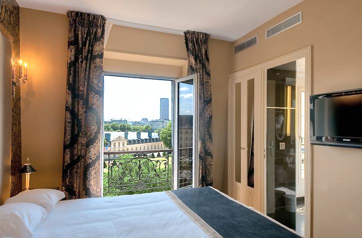
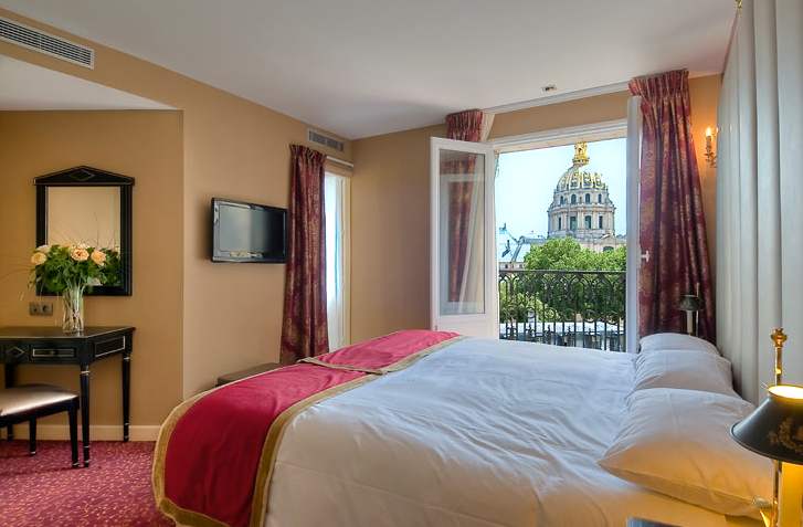
Hôtel de l’Empereur is one of the most stylish 2-star hotels around & just look at the views from the double-with-view rooms renovated in 2010. Free Wi-Fi, AC, large rooms & guiet Paris 7th location by Seine & Invalides. Over 150 past guest reviews rate this hotel a score of 8.6 of 10 at booking.com. We haven’t seen a nicer budget hotel in ages & qualifies for the best-price match guarantee from Booking.com.

One-stop shopping for car rental & international air travel deals:
Car rentals at competitive rates, no drop fees & a 5% discount for BonjourParis.com readers who use this link to Auto Europe Car Rental
Don’t overlook Auto Europe for international flights, click Auto Europe Flights
More in balzac, Boulogne, denfert, enceinte, French history, gaite, harpe, haussmann, history, Left Bank, map, marechaux, montrouge, octroi tax, Paris history, passy, peripherique, reuilly, Right Bank, st michel, walking tour
Related Articles